TransAtlas map shows spread of E85
July 8, 2009
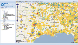
The U.S. DOE Alternative Fuels and Advanced Vehicles Data Center (AFDC), along with the National Renewable Energy Laboratory, have published the TransAtlas interactive map (http://rpm.nrel.gov/transatlas/launch), which uses a Google Maps interface to display locations of existing and planned E85 fueling stations, ethanol production facilities, and geographical flexible fuel vehicle density data. Users can customize the map by selecting the information to be displayed. The database for the TransAtlas map is maintained by NREL, which obtains information about new fueling stations from trade media, Clean Cities program coordinators, and a submittal form on the AFDC Web site.
Advertisement
Advertisement
Upcoming Events